Boushehr Province at a glance
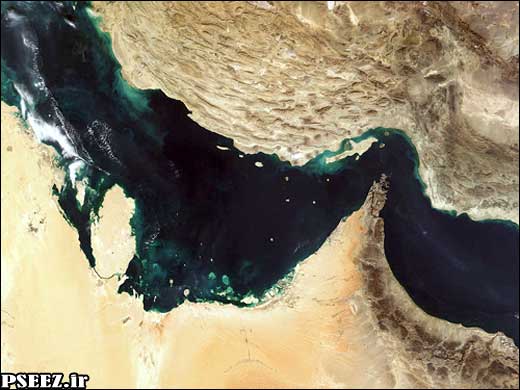
Boushehr province with an area of 27653 sq km is
located on the south of Iran, lying on the northern coastline
of the Persian Gulf. It is bordered by Khouzestan and Kohgiloyeh – va – Boyerahmad
provinces to the north, by Fars province to the east, by Hormozgan province on
its southeast, and by the Persian Gulf on the south and the west.
The population of the province stands at 743,675 people (1996 census ). Almost all the population
of the province speak Farsi with southern accents. Some inhabitants at Shif,
Kangan and Assaluyeh also speak Arabic.
The resistance of people of Boushehr, and brave warriors especially
Tangestan, against foreign invaders,formed an important part of the Iran’s contemporary
history and has left lasting memories for the people.
Boushehr province with more than 600 Km border with the Persian Gulf,
consists of 9 township and
22 cities. Its
townships are Boushehr (province’s center), Dashhtestan, Dashti, Tangestan,
Genaveh, Kangan, Dayer, Daylam, Jam and Riz.
South Pars Gas Field
South Pars gas field is the largest independent gas reserve
in the world which is shared by Iran and Qatar. The field is 105 kilometers away
from the Pars Special Economic Energy Zone. The reservoir
covers 9,700 square
kilometers in total with 3,700 square
kilometers blongingto Iran. According to latest figures, the field contains more than 51 trillion cubic meters of natural
gas . It stands for about 48 percent of
Iran’s confirmed reserves.
Considering the vast area of this gas field, its development
was planned in several phases. The aim of developing of South Pars is supplying
the increasing demand for the natural gas required for the country’s domestic consumption,
injecting gas into the oil fields, and exporting gas and condensates. Supplying
gas as feedstock for the petrochemical industry is on the agenda
of the National Iranian Oil Company (NIOC).
The field is already being developed in different phases; so
far 14 gas processing
plants have been planned. With regards to the reservoir’s capacity, the
development phases can increase to 28
phases or even more to further develop the giant gas field.Meanwhile,15 huge petrochemical complexes and a
wide range of downstream petrochemical units, different related
industries, semi-heavy industries, marine industries and considerable number of service
related facilities are predicted in this zone.
Area and Boundaries
The zone is bounded on the north by the Zagros Mountains, on
the south by the Persian Gulf, on the west by the village of Shirino and on the east by
the village of Chah Mobarak.
The total area is approximately 14,000 hectares. excluding the alluvial
lands and environmentally protected territories,there will remain
about 10,000 hectares of
developmental lands.
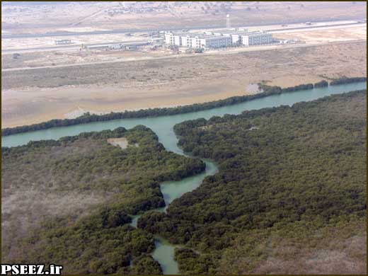
Preserved Land
The Nayband Bay is one of the most unique protected areas in
the south of Iran for the habitat and breeding of
marine life as well as mangrove trees.
Furthermore, the lands on the south of the Gavbandi River
and south-east of the PSEEZ are declared as Preserved Lands by the Environmental Protection
Organization of Iran.
Climate
• Located on the27 Degree latitude
and 52 degree
longitude.
• Air temperature of between 5 to 50 degrees centigrade.
• Relative humidity of 59 to 88 percent.
• Mean annual rainfall of 80 mm.
• The natural slope of the land starts from 0.1% (On the coastline) and reaches to 8% (on the mountain foot).
• Ground water reservoir of – 1.0 to – 10.0 m.
• Average and scattered vegetation with some densely covered
palm and mangrove trees.
• Predominant wind due to the particular local topography is
from northwest to southeast.